
Map shows where wildfires have forced evacuations across the US
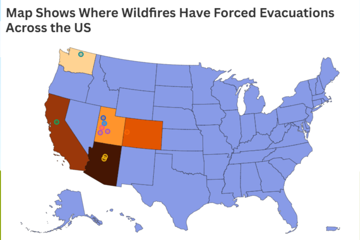
A series of fast-moving wildfires across the western United States has triggered evacuation orders in multiple states, with officials warning of continuing risk from extreme weather, dry fuels and shifting winds.
From Utah to Washington State, emergency responders and local authorities have issued urgent directives, with several fires burning out of control and, in some cases, resulting in fatalities.
Utah remains the epicenter of wildfire activity, with multiple large incidents driving evacuations across several counties. The biggest fires include:
Evacuations have affected the town of Eureka and surrounding communities, including Mammoth and Silver City. Officials estimated that, since the fire started on June 20, around 1,000 residents had been evacuated at one stage through Sunday, as the fire rapidly expanded beyond 13,000 acres, according to ABC News. The latest updates, according to the Utah Wildfire Dashboard, show that approximately 41,467 acres have been scorched, although at the time of publishing the fire is now 77 percent contained. KSL reports that evacuees have returned back to their homes.
The Cherry Fire, which merged with nearby blazes, prompted evacuations in Lofgreen, where residents were told by deputies, to "leave now," according to 2News.
The fire expanded rapidly, at one point covering tens of thousands of acres and forcing mandatory evacuations across multiple rural communities. The recent update provided by the Utah Wildfire Dashboard shows that, so far, the fire (which started on Friday, June 26) has ripped through 34,224 acres and remains only 22 percent contained.
🔥🚨 Utah declares State of Emergency as 10+ wildfires rage statewide—the Cottonwood Fire alone has scorched 92,000 acres and is 0% contained!
🌵💨 Record-low snowpack, extreme heat & strong winds have turned Utah into an inferno, forcing evacuations & closures across the…pic.twitter.com/Na9zoHeHwy
The Cottonwood Fire has become one of the largest in the county, burning more than 90,000 acres with 0 percent containment, the Utah Wildfire Dashboard shows.
Reports by AccuWeather say that mandatory evacuations were issued for Eagle Point Resort and surrounding residential areas, with the Beaver County Sheriff’s Office warning residents: "Gather medications, documents, and a go-kit. Ready your family, pets, and vehicle to leave quickly."
In central Utah, the Wild Goose Fire led to evacuations of homes north of Scipio, with nearby communities placed on standby as the fire burned more than 10,000 acres. The Utah Wildfire Dashboard reports that the fire remains only 3 percent contained.
🔥 #SnyderFire in 3D along the Utah—Colorado border. Satellite hotspots mapped with dense ground-level smoke drifting north. Track it live on FireMap pic.twitter.com/deb0B2e4RI
The Snyder Mesa Fire, formed by several lightning-caused blazes, has burned more than 28,000 acres with 0 percent containment and triggered pre-evacuation orders across parts of Mesa County.
Officials said the fire was fueled by strong winds and low humidity, prompting widening evacuation warnings.
The incident has also turned deadly. Three firefighters were killed and two others injured after being caught in a burnover while battling the blaze. The U.S. Wildland Fire Service said: "Their bravery, dedication, and sacrifice will never be forgotten."
The U.S. Wildland Fire Service is devastated to share that three wildland firefighters lost their lives on Saturday, June 27, as part of an interagency response to the Knowles and Gore fires along the Colorado-Utah border. Additionally, two crew members were injured in the line…pic.twitter.com/E2yubT21DW
On June 27, Colorado’s governor declared a disaster emergency, with authorities issuing closures of public lands and urging residents in affected areas to prepare to evacuate.
Smoke from the #PocketFire in Sedona has blanketed all of Flagstaff. Taken at 8:30am. #azwx @NWSFlagstaff pic.twitter.com/xxQAyQENrY
The Pocket Fire in northern Arizona forced evacuations in Oak Creek Canyon and nearby recreation areas, including "End of the World" and surrounding forest land. As of Monday, June 29, the fire has burned through over 9,000 acres and is 0 percent contained, according to Arizona Interagency Wildfire Prevention.
The U.S. Forest Service confirmed that visitors and residents were ordered to evacuate, Fox 10 News reported, with highways closed and shelters opened for displaced people.
Fire officials described a coordinated, multiagency response as crews attempted to protect homes and infrastructure around Sedona, with one local fire official noting the effort was focused on protecting "life, property and the beautiful nature we are surrounded by."
In Washington, the Hamilton Fire triggered Level 3 "GO NOW" evacuation orders, the highest level of alert, covering parts of Winthrop and eventually the entire town.
Okanogan County Emergency Management instructed residents to evacuate immediately, warning: "Persons should be aware of their surroundings and take action immediately."
The fast-moving fire, driven by wind, threatened homes and infrastructure, with evacuation centers set up in nearby Twisp.
In California, the Orange Fire in Sacramento County ignited on the afternoon of Friday, June 20, rapidly burning 1,200 acres in just 12 hours and forcing around 8,400 residents to evacuate across El Dorado Hills, Folsom and Fair Oaks.
Emergency shelters in Folsom reached 87 percent capacity as 20 mph winds and extremely dry conditions fueled the blaze’s rapid spread.
Across the western United States, wildfire activity has intensified under a combination of drought, high temperatures, and strong winds. Entire towns have been cleared, highways closed, and shelters opened as officials race to contain blazes that are expanding rapidly and, in some cases, merging into larger complexes.
The risks also extend to those on the front lines, with the deaths of three firefighters in Colorado showing just how dangerous the conditions are that emergency crews are facing.
As fire season intensifies, officials across multiple states continue to warn residents to monitor alerts closely and act immediately when evacuation orders are issued, as conditions can change within minutes.